The first significant regional snowfall of the season came with the arrival of a mild winter storm Sunday evening.
This item is available in full to subscribers.
Attention subscribers
To continue reading, you will need to either log in to your subscriber account, or purchase a new subscription.
If you are a current print subscriber, you can set up a free website account and connect your subscription to it by clicking here.
If you are a digital subscriber with an active, online-only subscription then you already have an account here. Just reset your password if you've not yet logged in to your account on this new site.
Otherwise, click here to view your options for subscribing.
Please log in to continue
Need an account?
Print subscribers
If you're a print subscriber, but do not yet have an online account, click here to create one.
Non-subscribers
Click here to see your options for becoming a subscriber.
Weather slows sugarbeet harvest
Posted
Shaun Evertson
KIMBALL, Neb. – The first significant regional snowfall of the season came with the arrival of a mild winter storm Sunday evening. As the weather front moved in during the afternoon, temperatures tumbled from the mid-60’s to mid-40’s and a northwest wind kicked up. Scattered drizzle and light rain began to fall at about 10:30 p.m., and as temperatures continued to fall, the rain transitioned to snow just after midnight. Light to moderately heavy snowfall persisted throughout the night and up until about 11 a.m. when warming air caused the snowfall to transition back to light rain.
By the time precipitation abated and the skies began to clear about four inches of wet snow had fallen, and that snow contained about 0.75 inches of liquid precipitation.
As the weather front passed and evening fell on Monday, the temperature began to drop sharply as warmth radiated away under cloudless night skies. Overnight temperatures plunged to 23 degrees, heralding the first hard freeze of the season.
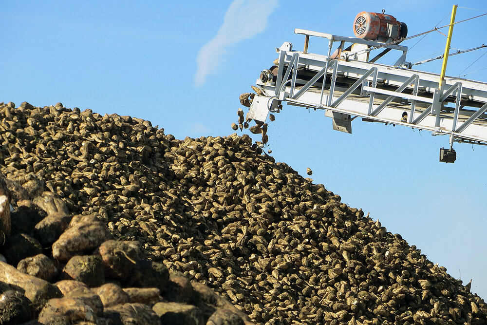
Sugarbeet harvest was in full swing over the last week and harvesters doubled their efforts to get the crop out of the field before the wintry storm arrived. On Saturday and Sunday from dawn to dusk a non-stop stream of beet trucks made their way to the sugarbeet receiving station north of Kimball.
Although good progress was made, the storm arrived before many producers could finish harvest. Rain and wet snow falling on unfrozen ground made for muddy fields, bringing harvest activities to a halt, leaving producers hopeful that a promised spell of warm, dry weather will allow for timely completion of the 2017 sugarbeet harvest.
Summer crops continued to mature over the last week with corn and sunflowers drying down nicely. Proso millet has been mostly harvested, as has much of the late-season hay crop.
The wet snow was beneficial to recently seeded winter wheat, but Monday night’s hard freeze may have been hard on newly-germinated stands. Pastures and rangeland also benefitted from the rain and wet snow.
Regional Forecast and Conditions
As of Tuesday morning, the temperature at sunrise was 23 degrees under clear skies. There was a substantial frost and hard freeze. The day was expected to be sunny with a high near 54 degrees.
The forecast through the weekend calls for mostly sunny skies. Weekend daytime air temperatures are forecast to range in the mid-50’ to 60 degrees. Overnight lows for the weekend are expected to fall into the low to mid-30’s.
Monday-Wednesday daytime highs are expected to range in the low 60’s, with overnight lows falling into the mid-30’s. There is a slight chance of widespread rain-snow showers through mid-week.
Air temperatures cooled slightly again across the region last week. At Kimball the Oct. 3-9 daytime high averaged 58.57 degrees, about 1 degree cooler than the previous week. The weekly high temperature was 77 degrees on Oct. 7. Overnight lows averaged 39.14 degrees, about 3 degrees cooler than the previous week. The weekly low temperature was 28 degrees on Oct. 9. The weekly mean temperature was 48.85 degrees, about 2 degrees cooler than the previous week, and just slightly warmer than the October average of 48.6 degrees. The long term average high and low temperatures at Kimball for October are 64.3 and 32.8 degrees, respectively.
Eleven of 13 Panhandle stations reported precipitation -- both snow and rain -- over the Oct. 3-9 period, with liquid equivalents ranging from 1.01 inches at Harrisburg to 0.22 inches at Harrison. Big springs and Sidney 0.9 NNW reported zero precipitation. Panhandle precipitation averaged 0.45 inches compared to 0.28 inches last week.
With the exception of Sidney, Panhandle soil temperatures cooled over the Oct. 3-9 period: (this week/last week/change): Alliance 51.8/55.7 (-3.9) degrees; Gordon 52.8/57.5 (-4.7) degrees; Mitchell 54.2/56.9 (-2.7) degrees; Scottsbluff 53.1/61.0 (-7.9); and Sidney 51.5/64.5 (-13.0) degrees.
Winds near Kimball averaged easterly and occasionally breezy over the Oct. 3-9 period. Gusts for the week averaged 27.0 mph. High gust for the week was 37 mph on Oct. 6.
Weather Almanac
Last year (Oct. 13, 2016): Daily high temperature 52 degrees, overnight low 27 degrees, average temperature 39.5 degrees. Precipitation 0.00 inches, snowfall zero inches, snow depth zero inches.
The warmest Oct. 13 on record was 89 degrees in 1996. The coolest Oct. 13 high temperature was 31 degrees in 1969. The coldest Oct. 13 overnight low was 18 degrees in 1969. The warmest Oct. 13 overnight low was 51 degrees in 1995. Over the years since 1893 the high temperature on Oct. 13 has averaged 63 degrees, the overnight low 32 degrees, the daily average 47.6 degrees, precipitation has averaged 0.04 inches, snowfall 0.1 inches, snow depth
zero inches.
The highest Oct. 13 precipitation total was 0.46 inches in 1957. The greatest snow depth was 7.0 inches in 1969.
Snow has fallen on Oct. 13 at Kimball three times over the last 123 years, with 1 inch in 1905 and a trace in 1969 and 1997.
U.S. Drought Monitor The High Plains: Beneficial rains (generally 2-5 inches) in the past 14-days have resulted in drought depiction improvements across North Dakota and eastern South Dakota this week. Accordingly, the impacts line was adjusted to better reflect the updated conditions across this area. In North Dakota, rainfall and cold temperatures halted agricultural progress where rainfall was significant. Short-term precipitation has been helpful, but needs to be weighed against long-term drought impacts.
West: In southeastern Arizona, the D0 “hole” in the depiction was filled in with D0, as there is little difference in conditions between that area and its surroundings. In Colorado, D0 was removed from the Denver area, and some D0 was trimmed away from Lake, Chaffee, and eastern Gunnison Counties. These locations received ample precipitation in September, and SPIs are mostly positive across multiple timescales. In eastern Utah (Uintah County), the western part of the moderate drought area (D1) was trimmed away. This area ended the Water Year with near average precipitation, and received above average precipitation in September. In Montana, welcome precipitation and increasing soil moisture warranted significant improvements statewide this week.
National Summary: A cold front approached the Eastern Seaboard early in the drought week, which drove Tropical Storm Maria farther away from the mid-Atlantic coast, keeping substantial impacts to a minimum. About the same time, the western edge of this cold front moved through southern Texas and New Mexico, bringing significant upslope precipitation (0.5-3.0 inches, locally greater) to the southern Great Plains and adjacent Rockies. Another cold front then moved southeastward out of central Canada, accompanied by primarily light precipitation (0.75-inch or less) to the Great Lakes region and Northeast. Towards the end of the drought week, yet another cold front progressed eastward across the Rockies, and the northern halves of the Great Plains and Mississippi Valley, bringing 1-2 inches of rain to much of the region.
For more information on the U.S. Drought Monitor visit: http://droughtmonitor.unl.edu
U.S. Conditions
and Weather Report
(Oct. 10) Due to the federal holiday, this report was not available at press time.
USDA Weekly Weather and Crop Reports
Colorado
For the week ending Oct. 8, fieldwork and harvest activities were hindered by wet conditions across much of the state.
Reporters in eastern districts again noted that moisture slowed winter wheat planting and harvest of spring crops, although progress was made as weather conditions allowed.
Pasture conditions in these areas that have not received enough moisture remain a concern.
Reporters in the San Luis Valley noted potato harvest progressed well around adverse weather events, but a lot of hay is still down waiting to dry out.
Across the state, livestock are reportedly doing well with some leaving summer pasture and more cattle producers starting to wean calves.
Statewide, corn was rated 62 percent good to excellent, compared with 74 percent last year and 56 percent on average. Most producers last week were still waiting for a hard frost before beginning corn harvest.
Stored feed supplies were rated 1 percent very short, 2 percent short, 84 percent adequate, and 13 percent surplus.
Sheep death loss was 2 percent heavy, 76 percent average, and 22 percent light. Cattle death loss was 1 percent heavy, 70 percent average, and 29 percent light.
Nebraska
Temperatures averaged near normal across western Nebraska, but four to eight degrees above normal in the east. Significant rainfall of an inch or more was received across most of the State, while some northeastern counties received up to four inches. Substantial amounts of precipitation continued to limit harvest activities. Topsoil moisture supplies rated 2 percent very short, 7 short, 68 adequate, and 23 surplus. Subsoil moisture supplies rated 4 percent very short, 16 short, 72 adequate, and 8 surplus. There were 1.9 days suitable for fieldwork.
Corn condition rated 4 percent very poor, 8 poor, 24 fair, 46 good, and 18 excellent. Corn mature was 83 percent, behind 91 last year, and near 87 for the five-year average. Harvested was 13 percent, behind 22 last year and 29 average.
Soybean condition rated 4 percent very poor, 8 poor, 26 fair, 49 good, and 13 excellent. Soybeans dropping leaves was 96 percent, near 94 last year and 93 average. Harvested was 23 percent, behind 42 last year, and well behind 46 average.
Winter wheat planted was 77 percent, behind 94 last year and 87 average. Emerged was 57 percent, behind 75 last year, but equal to average.
Sorghum condition rated 3 percent very poor, 2 poor, 20 fair, 54 good, and 21 excellent. Sorghum mature was 81 percent, behind 94 last year, and near 82 average. Harvested was 19 percent, behind 32 last year, and near 20 average.
Alfalfa fourth cutting was 89 percent complete, ahead of 83 last year, and near 87 average.
Dry edible beans harvested was 70 percent, behind 82 both last year
and average.
Proso millet harvested was 69 percent, behind 78 last year and
85 average.
Pasture and range conditions rated 3 percent very poor, 13 poor, 45 fair, 34 good, and 5 excellent.
Stock water supplies rated 1 percent very short, 4 short, 92 adequate, and
3 surplus.
Wyoming
Wyoming experienced cooler than normal temperatures for the week. Thirty-two of 34 reporting stations reported below average temperatures for the week with the high temperature of 78 degrees recorded at LaGrange, Old Fort Laramie and Torrington, and a low of 12 degrees at Laramie.
Below normal moisture was reported at 17 of the reporting stations with three stations (Greybull, Evanston, and Rock Springs) reporting no precipitation. Midwest reported the most moisture with 0.85 inches.
A reporter from North Central Wyoming said warmer days were slowing beet harvest with factories shutting down beet digging. They also indicated that bean harvest is slowly continuing with many beans still in the field.
A reporter from South Central Wyoming said, despite additional rain, planting is going well. They also indicated that livestock condition is good going into the fall.
A reporter from Western Wyoming noted the week started out dry with some producers trying for a third cutting of alfalfa, but for many, it has been too wet. They also reported that some producers are trying to finish up harvest of grain.
Stock water supplies across Wyoming were rated 10 percent very short, 14 percent short, 72 percent adequate, and 4 percent surplus.