Warmth and sunshine expected to follow rain and snow

Shaun Everston
Posted 5/19/17

Air temperatures warmed slightly over the previous week. Considerable precipitation fell as rain early in the reporting period in and around Kimball and much of the rest of the Panhandle.

This item is available in full to subscribers.

Please log in to continue

Log in

Warmth and sunshine expected to follow rain and snow

Posted

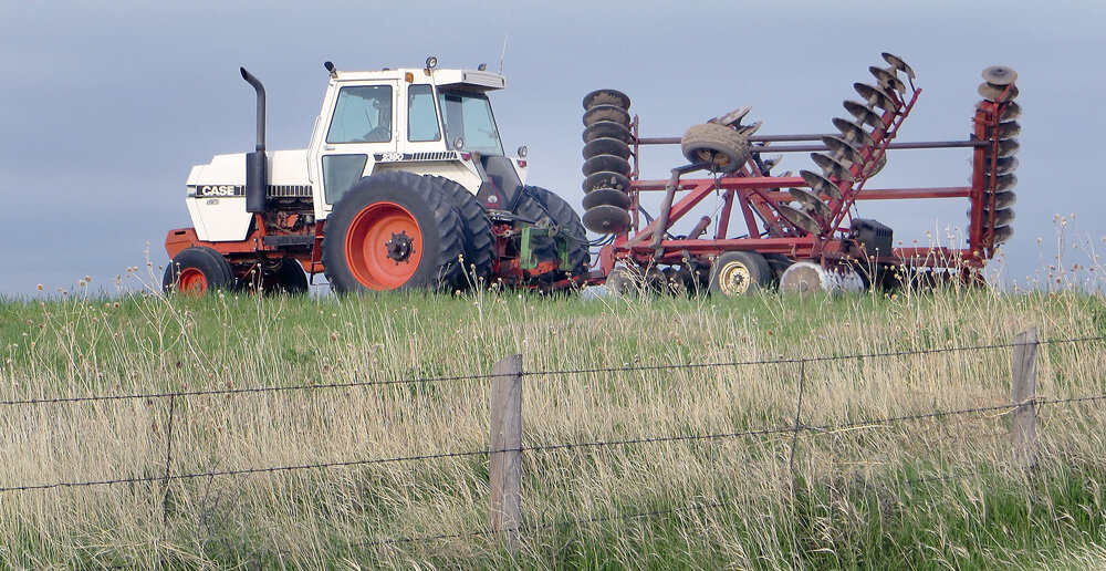
KIMBALL – Air temperatures warmed slightly over the previous week. Considerable precipitation fell as rain early in the reporting period in and around Kimball and much of the rest of the Panhandle.
Conditions warmed and clear skies and sunshine quickly dried fields, allowing producers to conduct tillage and spraying operations, as well as some planting.
Cattle continued to flow from winter quarters to spring grass, with many cows and calves in excellent condition.
Across pastures and rangeland, cool season grasses are hitting rapid growth windows as air temperatures hit May norms. Larkspur has yet to begin flowering, while death camas has reached flowering.

Regional Forecast and Conditions
As of Tuesday, May 16, conditions remained warm and dry. Cool temperatures and widespread rain and even snow were in the forecast through Friday (today) with the expected arrival of a slow moving weather front. The front is expected to pass out of the tri-state region Friday night with warmth and sunshine forecast through the middle of next week. Today’s high is only expected to reach 38 degrees, with tonight’s low falling to near freezing. Rain and snow are expected through midday.
Daytime highs Saturday-Wednesday are expected to range in the upper 50’s to mid-60’s, with overnight lows falling into the upper 30’s to low-40’s. Clear skies and sunshine are forecast during this period with the usual springtime chance of scattered, localized thunderstorms.
Air temperatures warmed slightly across the region last week. At Kimball the May 9-15 daytime high averaged 69.57 degrees, slightly cooler than the previous week. The weekly high temperature was 82 degrees on May 13. Overnight lows averaged 46.57 degrees, about 5 degrees warmer than the previous week. The weekly low temperature was 41 degrees on
May 11.
The weekly mean temperature was 58.07 degrees, about 3 degrees warmer than the previous week, and about 3 degrees warmer than the May average of 55.0 degrees. The long term average high and low temperatures at Kimball for May are 69.3 and 40.7 degrees, respectively.
Twelve of 13 Panhandle stations reported precipitation over the May 9-15 period, ranging from 1.89 inches at Agate to 0.03 inches at Sidney Municipal. Dalton reported zero precipitation for the week. Panhandle precipitation averaged 0.71 inches for the week, compared to 0.15 inches last week.
Soil temperatures warmed last week, ranging from 3.3 to 5.7 degrees warmer than the previous week across the Panhandle. May 9-15 soil temperatures (this week/last week/change): Alliance 60.9/55.4 (+5.5) degrees; Gordon 60.3/57.0 (+3.3) degrees; Mitchell 62.4/56.7 (+5.7) degrees; Scottsbluff 61.1/55.4 (+5.7); and Sidney 62.4/58.0 (+4.4) degrees.
Winds near Kimball averaged easterly and occasionally breezy. Gusts for the week averaged 25.28 mph. High gust for the week was 32 mph on May 14.

May 19 Weather Almanac
Here’s an overview of May 19 temperature and precipitation highs, lows, and averages over the preceding 123 years at Kimball. Data is taken from the High Plains Regional Climate Center (www.hprcc.unl.edu), where you can easily find and track data for your own
particular location.
Last year (May 19, 2016): Daily high temperature 63 degrees, overnight low 37 degrees, average temperature 50.0 degrees. Precipitation 0.00 inches, snowfall zero inches, snow depth zero inches.
The warmest May 19 on record was 95 degrees in 1925. The coolest May 19 high temperature was 45 degrees in 1981. The coldest May 19 overnight low was 29 degrees in 1931. The warmest May 19 overnight low was 59 degrees in 1948. Over the years since 1893 the high temperature on May 19 has averaged 68 degrees, the overnight low 42 degrees, the daily average 55.3 degrees, precipitation has averaged 0.09 inches, snowfall zero inches, snow depth zero inches.
The greatest May 19 precipitation recorded over the last 123 years was two inches in 1988.
Snow has fallen on May 19 at Kimball 3 times over the last 123 years. The greatest May 19 snowfall was a trace in 1979. Measurable May 19 snow depth was reported in zero of the last 123 years. May 19 snow depth was zero inches throughout the period of record.

U.S. Drought Monitor
As of May 11
The High Plains: Much of the region was drier than normal this week, with only portions of eastern Colorado and southern Kansas recording above-normal precipitation. Temperatures were warmer than normal over most of the region, with departures of 6-8 degrees above normal in the Dakotas. Colorado had abnormally dry conditions removed from the southeast portion of the state, and the moderate drought and abnormally dry conditions in the northern portion of the state also improved. Abnormally dry conditions were introduced over much of northern South Dakota and expanded in southern North Dakota. The short-term dryness in this region has helped to progress agricultural work, but may become an issue without some needed rains.
National Summary: The Midwest continued to be inundated with heavy rains from southern Kansas through Missouri and into southern Illinois and Indiana. Amounts associated with the Midwest rains were generally in the 1-3 inch range, with locally higher amounts. Much of the eastern United States was wet over the last week; many areas recorded above-normal precipitation and the rains kept temperatures below normal, with departures of 10 degrees or more over the Midwest. Over the weekend, heat returned to the Southwest with several days of temperatures above 100 degrees F while most of the western half of the United States had above-normal temperatures with departures of 6-8 degrees above normal in the Dakotas and northern Rocky Mountains. Much of the West and Plains were dry for the week, with just scattered thunderstorms in the Rocky Mountains and rains along the coastal areas of the Pacific Northwest.
For more information on the U.S. Drought Monitor visit: http://droughtmonitor.unl.edu

U.S. Conditions and Weather Report
As of May 16, stormy weather continued across the central Plains, mid-South, and parts of the Midwest, perpetuating fieldwork delays and prolonging
lowland flooding.
Heavy rain eventually spread across portions of the northern Atlantic States, helping to erase the final vestiges of last year’s drought.
Most other areas of the country received only light precipitation, allowing fieldwork to proceed or accelerate.
Some of the most significant planting progress took place across the northern Plains and upper Midwest, where warmth accompanied the mostly dry weather.
Crops in California also benefited from mostly dry weather, as well as a short-lived warm spell.

Warmth across the northern and central Plains and the western Corn Belt boosted weekly temperatures as much as 5 to 10 degrees above normal.
Persistently cool weather prevailed from the lower Great Lakes region into the Northeast, holding weekly temperatures as much as 10 degrees
below normal.
Late-season freezes struck portions of the Great Lakes region from May 7-9, leading producers to monitor fruit crops, as well as heading winter wheat and emerged corn, for signs of injury.
Elsewhere, a few showers dotted the lower Southeast, where most areas would benefit from a soaking rain to reduce irrigation demands and ease stress on pastures and rain-fed crops.

Water supply forecast
Cool, showery weather in April postponed the melt season and sustained much of the high elevation snowpack in northern and central California and the Northwest. In contrast, warm, seasonably dry weather prevailed in the Desert Southwest, melting any remaining snow and bringing short-term drought back into focus. Short-term dryness also intensified during April across parts of eastern Utah and western Colorado. Considerable dense snow—with an average water content of about 43 inches, according to the California Department of Water Resources—remained on the ground at the end of April in the Sierra Nevada. Many Northwestern basins also retained impressive high-elevation snow into May, promising a robust and extended melt period that could help shorten the wildfire season.

Snowpack and Precipitation
By May 15, most basins in northern and central California and the Northwest were reporting much-above-normal snowpack for this time of year. In contrast, snow has already melted across much of the Southwest, except in the Rockies of northern New Mexico. A few basins in Montana and the central Rockies were noting deficient snowpack, roughly 50 to 75 percent of the mid-May average. Season-to-date precipitation (Oct. 1, 2016 – May 15, 2017) was near or above normal throughout the West, highlighting the impressive array of storms that have reached into every corner of the region. Further, seasonal precipitation totals have been truly exceptional—at least 200 percent of normal—in the Sierra Nevada and scattered basins across the northern Intermountain West.

Spring and Summer Stream-flow Forecasts
By May 1, projections for spring and summer stream-flow were indicating the likelihood of near- or above-normal runoff in many Western watersheds. In particular, runoff in excess of 180 percent of average can be expected from the Sierra Nevada to the northern Intermountain West. In contrast, runoff volumes of less than 90 percent of average should occur in several watersheds in Montana and the central and southern Rockies.

Reservoir Storage
On May 1, reservoir storage as a percent of average was near or above average in all Western States except New Mexico and Washington. New Mexico’s low storage was a combination of several factors, including the lingering effects of a multi-decade drought and overtaxed water supplies. Hydrologically, Washington has few concerns and continued to prepare for robust spring and summer runoff by keeping some reservoirs low. Meanwhile, California’s May 1 statewide storage stood at 111 percent of average, down from 122 percent 2 months earlier, as reservoir managers lowered lake levels to prepare for runoff during the next several months.

USDA Weekly Weather and Crop Reports

Colorado
Widespread precipitation was reported throughout much of the state this past week.
Warmer weather to finish the week accelerated planting and crop development in areas that were hindered earlier in
the week.
Moisture received continues to aid pasture, crop, and soil moisture conditions, but some localities reported
severe weather.
Crop damage was reported in Weld County from an isolated hailstorm and heavy rain Monday.
A reporter noted heavy losses to sugarbeets, alfalfa, and newly-seeded corn. Incidences of wheat stripe rust were again noted in East Central counties.
The San Luis Valley received good moisture last week, but a reporter noted freeze damage to some crops,
including alfalfa.
Statewide, winter wheat remained mostly in good to fair condition, although a reporter in the Southeast district noted the crop is significantly damaged in areas that received heavy snow two weeks ago.
Throughout most of the state, livestock are doing well with many being moved to summer pasture.
As of May 11, snowpack in Colorado was at 100 percent measured as a percentage of median snowfall. The Southwest and San Luis Valley were 118 and 117 percent,
respectively.
Stored feed supplies were rated 5 percent short, 87 percent adequate, and 8
percent surplus.
Sheep death loss was 65 percent average and 35 percent light. Cattle death loss was 1 percent heavy, 75 percent average, and 24 percent light.
Nebraska
For the week ending May 14, temperatures averaged four to six degrees above normal.
Rainfall accumulations of an inch were common in Panhandle, south-central, and southwestern counties, but limited to half an inch or less for the rest of the State.
Topsoil moisture supplies rated 3 percent very short, 14 short, 79 adequate, and 4 surplus. Subsoil moisture supplies rated 4 percent very short, 14 short, 78 adequate, and 4 surplus.
Dry, warm weather allowed farmers to make progress in corn and soybean planting. There were 5.1 days suitable
for fieldwork.
Corn planted was 78 percent, ahead of 71 last year, and near 76 for the five-year average. Emerged was 31 percent, near 28 last year and
34 average.
Soybeans planted was 37 percent, ahead of 27 last year, but equal to average. Emerged was 4 percent, near 3 last year and 7 average.
Winter wheat condition rated 2 percent very poor, 12 poor, 40 fair, 41 good, and 5 excellent. Winter wheat jointed was 94 percent, near 90 last year, and ahead of 76 average. Headed was 32 percent, near 31 last year, and ahead of
22 average.
Sorghum planted was 14 percent, near 12 last year, but behind 19 average. Emerged was 1 percent.
Oats condition rated 0 percent very poor, 0 poor, 15 fair, 81 good, and 4 excellent. Oats planted was 99 percent, ahead of 92 last year, and near 97 average. Emerged was 95 percent, ahead of 85 both last year and average. Jointed was
16 percent.
Pasture and range conditions rated 0 percent very poor, 3 poor, 29 fair, 59 good, and
9 excellent.
Stock water supplies rated 1 percent very short, 3 short, 94 adequate, and 2 surplus.

Wyoming
Wyoming experienced warmer than normal temperatures for the week. All 34 stations reported above average temperatures for the week with the high temperature of 89 degrees recorded at Torrington and a low of 18 degrees at
Big Piney.
All 34 stations reported some precipitation with Big Piney having the most at 0.73 inches and Buffalo-Johnson having the least with 0.02 inches. Only three stations had more than average precipitation.
A reporter from north-central Wyoming indicted that rain continues to add to the greening of the pastures, planting is in full swing, livestock look good and branding and docking is
underway.
A reporter from northeastern Wyoming stated that additional precipitation is needed.
A reporter from eastern Wyoming noted that things are improving. Subsoil moisture is reported as low, so current conditions may not last.
A reporter from western Wyoming indicated that farming is underway, weather has been good and flooding is at full swing.
A reporter from southwestern Wyoming stated that they are dealing with excessive runoff and flooding. They also indicated that cooler temperatures are forecasted which should slow the snow melt.
A reporter from south-central Wyoming said they are still in need of moisture for sustained pasture growth and
irrigation needs.
A reporter from southeastern Wyoming stated the area has received very little moisture which, combined with cool temperatures and wind, has resulted in dry conditions and minimal grass growth. However, another reporter from southeast Wyoming reported very good grazing prospects for this year in their
local area.
Stock water supplies across Wyoming were rated 7 percent very short, 6 percent short, 71 percent adequate, and 16
percent surplus.