Cool temperatures and rain were once again the weather story across the Panhandle of Nebraska and much of the tri-state region last week.
This item is available in full to subscribers.
Attention subscribers
To continue reading, you will need to either log in to your subscriber account, or purchase a new subscription.
If you are a current print subscriber, you can set up a free website account and connect your subscription to it by clicking here.
If you are a digital subscriber with an active, online-only subscription then you already have an account here. Just reset your password if you've not yet logged in to your account on this new site.
Otherwise, click here to view your options for subscribing.
Please log in to continue
Need an account?
Print subscribers
If you're a print subscriber, but do not yet have an online account, click here to create one.
Non-subscribers
Click here to see your options for becoming a subscriber.
Warmer, drier conditions expected next week
Posted
Shaun Everston
KIMBALL – Cool temperatures and rain were once again the weather story across the Panhandle of Nebraska and much of the tri-state region last week.
A slow moving weather front began to pass through the region last Thursday (May 25) bringing cooler air temperatures, breeziness, and widespread thundershowers. A friday thunderstorm delivered just over an inch of rain south of I-80 in Kimball County, while north of I-80 the total was considerably less. This storm also delivered a good deal of pea-to marble-sized hail.
As the weather front slowly moved out over the long weekend air temperatures remained slightly cooler than average and there was a good deal of breeziness.
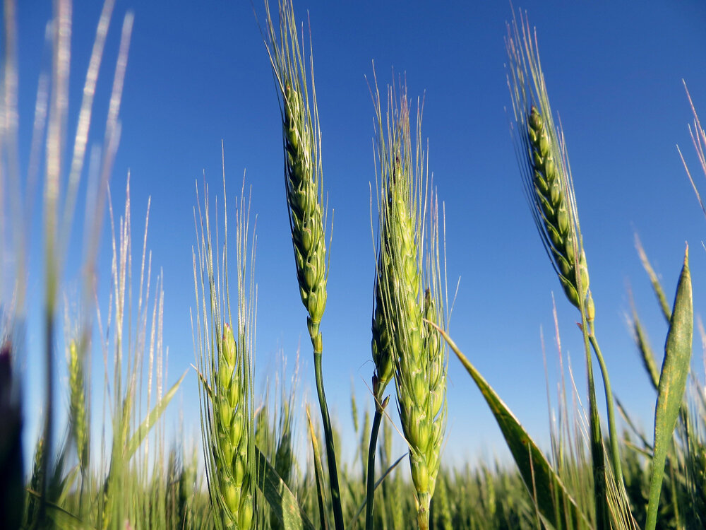
Near Kimball winter wheat is well along in heading and will be flowering soon. Producers are generally behind in planting summer crops due to wet fields, and these same conditions have slowed tillage and spraying operations. Aerial applicators have been busy however.
Pastures and rangeland continue to develop nicely if slightly behind average due to cooler air temperatures. Cool season grasses are well into rapid growth and producing abundant biomass. Western wallflower and evening primrose are flowering, and larkspur is beginning to flower.
Regional Forecast and Conditions
As of Tuesday, May 30, conditions at Kimball were sunny and clear and expected to remain so through the weekend and into the middle of
next week.
Daytime highs through Wednesday, June 7 are expected to range in the mid-80’s with overnight lows falling into the mid- to upper-40’s. Skies are expected to be mostly sunny and clear during this period with the usual springtime chance of scattered, localized thunderstorms.
Air temperatures warmed across the region last week. At Kimball the May 23-29 daytime high averaged 68.57 degrees, about 11 degrees warmer than the previous week. The weekly high temperature was 82 degrees on May 24. Overnight lows averaged 41.57 degrees, about 4 degrees warmer than the previous week. The weekly low temperature was 37 degrees on May 23-24. The weekly mean temperature was 55.07 degrees, about 11 degrees warmer than the previous week, and very close to the May average of 55.0 degrees. The long term average high and low temperatures at Kimball for May are 69.3 and 40.7 degrees, respectively.
All 13 Panhandle stations reported precipitation over the May 23-29 period, ranging from 1.11 inches at Kimball to 0.26 inches at Sidney Municipal. Panhandle precipitation averaged 0.51 inches compared to 2.25 inches last week.
Soil temperatures warmed last week, ranging from 4.1 to 2.4 degrees warmer than the previous week across the Panhandle. May 23-29 soil temperatures (this week/last week/change): Alliance 57.1/53.8 (+3.3) degrees; Gordon 58.1/54.0 (+4.1) degrees; Mitchell 57.3/55.9 (+1.4) degrees; Scottsbluff 56.2/54.5 (+1.7); and Sidney 58.1/55.2 (+2.9) degrees.
Winds near Kimball averaged west-northwesterly and often breezy over the May 23-29 period. Gusts for the week averaged 30.57 mph. High gust for the week was 38 mph on May 26 and 29.
June 2 Weather Almanac
Overview of June 2 temperature and precipitation highs, lows, and averages over the preceding 123 years at Kimball. Data is taken from the High Plains Regional Climate Center (www.hprcc.unl.edu), where you can easily find and track data for your own particular location.
Last year: Daily high temperature 71 degrees, overnight low 46 degrees, average temperature 58.5 degrees. Precipitation 0.17 inches, snowfall zero inches, snow depth zero inches.
The warmest June 2 on record was 94 degrees in 2002. The coolest June 2 high temperature was 44 degrees in 1951. The coldest June 2 overnight low was 30 degrees in 1951. The warmest June 2 overnight low was 59 degrees in 1896. Over the years since 1893 the high temperature on June 2 has averaged 73 degrees, the overnight low 47 degrees, the daily average 59.7 degrees, precipitation has averaged 0.11 inches, snowfall zero inches, snow depth zero inches.
The highest June 2 precipitation recorded over the last 123 years was 2.23 inches in 1961.
Snow has not fallen at Kimball on June 2 over the last 123 years.
U.S. Drought Monitor
(May 23) The High Plains: A stripe of heavy precipitation from the central Rockies into the upper Midwest erased pockets of abnormal dryness (D0) in Nebraska and reduced coverage of dryness and moderate drought (D0 and D1) in Colorado.
Rain also trimmed D0 coverage in the eastern Dakotas. However, precipitation mostly bypassed the remainder of the Dakotas, leading to further expansion of D0. In addition a new area of moderate drought (D1) was introduced in the vicinity of the Missouri River.
On May 21, South Dakota led the entire northern U.S. in topsoil moisture rated very short to short (29 percent), as well as rangeland and pastures rated very poor to poor (19 percent), according to the U.S. Department of
Agriculture.
National Summary: Soaking precipitation occurred from central portions of the Rockies and Plains into the upper Midwest, mainly from May 16-18, and in parts of the Southeast starting on May 20. Drought-affected areas of the Southeast, including portions of Alabama and Georgia, experienced substantial relief, with rain still falling when the drought-monitoring period ended on May 23.
Farther west, late-season snow (locally 1 to 3 feet) blanketed the northern and central Rockies, while streaks of heavy rain largely arrested drought development in the south-central U.S. Areas that remained stubbornly dry included parts of the north-central U.S. and Florida’s peninsula, although significant rainfall developed in the latter region after the monitoring period ended on May 23.
For more information on the U.S. Drought Monitor visit: http://droughtmonitor.unl.edu
U.S. Conditions and Weather Report
The May 31 report was not available at press time.
USDA Weekly Weather and Crop Reports
Colorado
Northern Colorado experienced mixed weather in the form of isolated hail and heavy rains that halted fieldwork while southern Colorado experienced milder weather ideal for planting last week.
Some crop damage from the hail was reported in northeastern Colorado affecting corn, wheat, alfalfa and sugar beets.
Non-irrigated crops that were planted and rangeland in Northern Colorado benefited greatly from last week’s precipitation.
As of May 30th, snowpack in Colorado was at 188 percent measured as percent of median snowfall. The Southwest and San Luis Valley were 201 and 156 percent, respectively.
Several locations reported pest control problems for the alfalfa crop.
The barley crop was looking good and potatoes were beginning to emerge in the San Luis Valley.
Statewide, winter wheat remained mostly in good to fair condition.
Stored feed supplies were rated 4 percent short, 87 percent adequate, and 9 percent surplus.
Sheep death loss was 68 percent average and 32 percent light. Cattle death loss was 1 percent heavy, 76 percent average, and 23 percent light.
Nebraska
Cool and mostly dry conditions prevailed for the week ending May 28.
Average temperatures ranged from three to nine degrees below normal.
Some areas of the panhandle and southeast Nebraska received up to an inch of rain; however, much of the State remained dry. This allowed soils to dry out, and producers continued to plant and cut hay.
Topsoil moisture supplies rated 0 percent very short, 7 short, 85 adequate, and 8 surplus. Subsoil moisture supplies rated 1 percent very short, 6 short, 86 adequate, and 7 surplus.
There were 4.5 days suitable for fieldwork.
Corn condition rated 0 percent very poor, 4 poor, 20 fair, 68 good, and 8 excellent. Corn planted was 95 percent, equal to last year, and near 97 for the five-year average. Emerged was 76 percent, near 74 last year and 80 average.
Soybeans planted was 76 percent, ahead of 70 last year, but near 79 average. Emerged was 35 percent, near 33 last year, but behind 44 average.
Winter wheat condition rated 2 percent very poor, 10 poor, 41 fair, 39 good, and 8 excellent. Winter wheat headed was 86 percent, ahead of 68 last year, and well ahead of 55 average.
Sorghum planted was 50 percent, near 51 last year, and behind 58 average. Emerged was 17 percent.
Oats condition rated 0 percent very poor, 0 poor, 22 fair, 67 good, and 11 excellent. Oats jointed was 76 percent, well ahead of 55 last year. Headed was 31 percent, ahead of 20 both last year and average.
Alfalfa condition rated 0 percent very poor, 1 poor, 18 fair, 69 good, and 12 excellent. Alfalfa first cutting was 25 percent, near 28 last year, and behind 30 average.
Dry edible beans planted was 1 percent, behind 10 last year and 16 average.
Proso millet planted was 4 percent.
Pasture and range conditions rated 0 percent very poor, 1 poor, 20 fair, 66 good, and 13 excellent.
Stock water supplies rated 0 percent very short, 2 short, 93 adequate, and 5 surplus.
Wyoming
Wyoming experienced cooler than normal temperatures for the week. All but one station (Evanston) reported cooler than average temperatures for the week. The high temperature of 88 degrees recorded at Greybull and a low of 24 degrees at Shirley Basin.
All 34 stations reported some precipitation with Cheyenne having the most at 0.74 inches and Rock Springs having the least with 0.02 inches. Twenty-nine stations had less than average precipitation.
A reporter from North Central Wyoming indicted that they received some more rain last week and they are planting as they can. They also indicated that the grass is green and they have water in the reservoirs.
A reporter from Western Wyoming indicated that the weather has changed from cool and wet, to hot and dry. They also indicated that the high elevation snowpack is melting, livestock have been moved to the range, and a lot of small grains were planted.
A reporter from Southwestern Wyoming stated that it was a little chilly last week, but mostly good weather.
A reporter from South Central Wyoming commented that it was cool and rainy. They got enough moisture for a start but it will not last long. Another reporter from South Central Wyoming stated that they got about a third of an inch of moisture and the grass is starting to green with the warmer temperatures.
A reporter from Southeastern Wyoming noted that they have a very good peak of growing season rangeland conditions. Another reporter from Southeast Wyoming reported that they have had a lot of moisture recently, which has halted planting and field work. They also indicated that the cool temperatures might hurt yields.
Stock water supplies across Wyoming were rated 4 percent very short, 4 percent short, 78 percent adequate, and 14 percent surplus.