Seasonal August warmth and dryness returned to the tri-state region over the last week.
A pause in the southwest monsoon and some upper air ridging made for mostly sunny skies which produced little rain across the region.
This item is available in full to subscribers.
Attention subscribers
To continue reading, you will need to either log in to your subscriber account, or purchase a new subscription.
If you are a current print subscriber, you can set up a free website account and connect your subscription to it by clicking here.
If you are a digital subscriber with an active, online-only subscription then you already have an account here. Just reset your password if you've not yet logged in to your account on this new site.
Otherwise, click here to view your options for subscribing.
Please log in to continue
Need an account?
Print subscribers
If you're a print subscriber, but do not yet have an online account, click here to create one.
Non-subscribers
Click here to see your options for becoming a subscriber.
Warm, dry weather returns to the tri-state
Posted
Shaun Everston
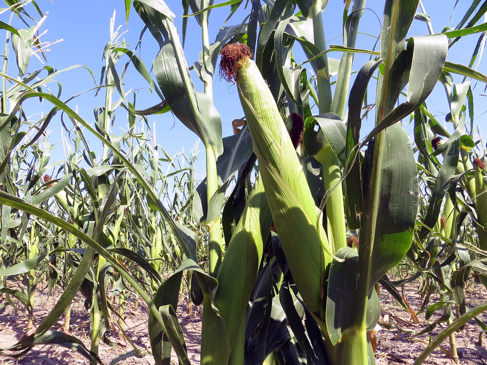
KIMBALL – Seasonal August warmth and dryness returned to the tri-state region over the last week.
A pause in the southwest monsoon and some upper air ridging made for mostly sunny skies which produced little rain across the region.
Near Kimball, the effects of rainfall earlier in the month remain evident in strong looking stands of dryland millet, sunflower, corn, and forage crops.
Well managed pastures and rangeland remain green with continued warm season grass growth.
The last week of warm and dry weather did tend to deplete near-surface soil moisture and additional rainfall would be welcome going into late summer and early autumn.
Regional Forecast and Conditions
As of Tuesday morning, Aug. 22, the temperature at sunrise was 54 degrees under mostly cloudy skies. The day was expected to be mostly sunny with a high of 81 degrees and little chance of rain.
The forecast through the weekend and into the middle of next week calls for continued seasonably warm and dry conditions. Daytime temperatures were expected to range in the lower- to mid-80’s with little if any precipitation in the forecast. A chance of afternoon and evening thunderstorms remains in effect across the region.
Air temperatures warmed across the region last week. At Kimball the Aug. 15-21 daytime high averaged 83.71 degrees, about 5.5 degrees warmer than the previous week. The weekly high temperature was 93 degrees on Aug. 19. Overnight lows averaged 54.42 degrees, about one-half degree warmer than the previous week. The weekly low temperature was 50 degrees on Aug. 17. The weekly mean temperature was 69.07 degrees, about 3 degrees warmer than the previous week, and 1 degree cooler than the August average of 70.0 degrees. The long term average high and low temperatures at Kimball for August are 85.9 and 54.2 degrees, respectively.
All 13 Panhandle stations reported precipitation over the period. Rainfall totals ranged from 0.65 inches at Big Springs to 0.07 inches at Scottsbluff. Panhandle precipitation averaged 0.29 inches compared to 0.51 inches last week.
Panhandle soil temperatures warmed slightly over the period: (this week/last week/change): Alliance 71.3/67.0 (+4.3) degrees; Gordon 72.4/70.0 (+2.4) degrees; Mitchell 72.7/71.2 (+1.6) degrees; Scottsbluff 72.9/71.6 (+1.3); and Sidney 70.4/68.2 (+2.2) degrees.
Winds near Kimball averaged westerly and mostly calm over the August 15-21 period. Gusts for the week averaged 24.14 mph. High gust for the week was 40 mph on August 15.
Weather Almanac
Here’s an overview of Aug. 25 temperature and precipitation highs, lows, and averages over the preceding 123 years at Kimball. Data is taken from the High Plains Regional Climate Center (www.hprcc.unl.edu), where you can easily find and track data for your own particular location.
Last year: Daily high temperature 70 degrees, overnight low 41 degrees, average temperature 55.5 degrees. Precipitation 0.02 inches, snowfall zero inches, snow depth zero inches.
The warmest Aug. 25 on record was 101 degrees in 1926. The coolest high temperature was 50 degrees in 1992. The coldest overnight low was 26 degrees in 1910. The warmest overnight low was 63 degrees in 1961. Over the years since 1893 the high temperature on has averaged 82 degrees, the overnight low 53 degrees, the daily average 67.3 degrees, precipitation has averaged 0.05 inches, snowfall zero inches, snow depth zero inches.
The highest precipitation total was 1.48 inches in 1933.
U.S. Drought Monitor As of Aug. 15
The High Plains: With the recent rainfalls, conditions returned to normal in northwestern Kansas along the Nebraska border and across extreme southern Kansas.
In southwestern Nebraska, moderate drought shrank (D1) in Perkins, Chase, Hayes, and Lincoln Counties, following precipitation totals of up to nearly 4 inches. Likewise in the Nebraska panhandle, normal conditions prevail once again across eastern Box Butte, northeastern Morrill county, and northern Garden Counties, thanks to precipitation totals of 1.5-2.5 inches over the past week.
Conditions improved to abnormally dry (D0) in parts of Custer, Blaine, and Loup counties in central Nebraska after two consecutive nights of heavy rainfall. Moderate drought also shrank slightly in north central Holt and south central Boyd counties, where up to 3.5 inches of rain fell. And normal conditions returned to a swath from Ewing to Atkinson in Holt County.
Heavy rain also erased remaining dryness in Laramie County, Wyoming.
Some areas in South Dakota received 3-7 inches of rain over the past week, contributing to improving conditions in some northeastern, north central, and south central pockets. However, the west was not as fortunate. Extreme drought (D3) creeped farther west in Meade County while severe drought (D2) expanded in Jackson.
In southwestern North Dakota, rainfall helped alleviate exceptional drought (D4, the worst category), although due to the extremely poor growing conditions, it remained around the Hettinger County area.
Conditions also improved in Colorado. Normal conditions returned around the Denver metro area and in Phillips County in the northeastern corner of the state.
National Summary: Temperatures were cooler than average for much of the contiguous U.S. this week, including 4-8 degrees below average across a large part of the Plains and Midwest this past week.
Washington and Oregon saw temperatures more than 4 degrees above average for the period.
With the below-average temperatures came a lot of rain in some regions, notably across northern Texas and much of Oklahoma, where rainfall was more than 600 percent of normal for this time of year.
There were also substantial rains in parts of Wyoming, Nebraska, parts of the Dakotas, and in many places across the southeast.
Rainfall was below average in southern Texas, parts of the midwest, northeast, and northwest, particularly notable in Montana where wildfires are prevalent.
For more information on the U.S. Drought Monitor visit: http://droughtmonitor.unl.edu
U.S. Conditions and Weather Report As of Aug. 22
Showers and thunderstorms continued to pepper much of the central and eastern U.S., with some of the heaviest rain occurring across the southeastern Plains, mid-South, and upper Midwest.
Rain largely bypassed a few areas, namely the western Gulf Coast region and a broad section of the central and eastern Corn Belt.
Warm weather returned to the Midwest, following an unusually cool start to August, boosting moisture demands for filling summer crops.
Hot, steamy weather across the South, accompanied by scattered showers and abundant soil moisture reserves, maintained a greenhouse-like environment for pastures and immature summer crops.
Drought-easing rain continued to fall across parts of the northern Plains, helping to revive rangeland and pastures and aiding later-planted summer crops, such as soybeans. Precipitation was especially heavy in parts of Nebraska, where rainfall locally totaled 4 to 6 inches or more.
Little rain fell, however, in Montana, where pasture and crop conditions continued to deteriorate and several large wildfires remained active.
Similarly, hot, dry weather returned to the Northwest, where several fires continued to burn. In fact, a brief lull in the Southwestern monsoon circulation led to mostly dry weather and a warming trend in many other areas of the western U.S.
Elsewhere, spotty downpours across the southern Plains and mid-South sparked local flooding but generally benefited summer crops.
USDA Weekly Weather and Crop Reports
Colorado
Isolated precipitation was received in several Colorado counties this past week, continuing to provide beneficial moisture but delaying fieldwork in a few areas. In northwestern counties, only spotty moisture has been received.
A reporter noted that hay and pasture conditions in several areas are drought stressed, with below normal yields reported for hay. Livestock water for rangeland in these counties remains critically low.
Northeastern counties received rain this past week, with heavy amounts reported in areas. Cooler conditions continue to provide relief from dry conditions and seasonal heat. Dryland crops are improving with precipitation, but rangeland is dry in areas and in need of moisture.
A reporter noted that a shortage of moisture in weeks prior negatively affected grain fill in some corn.
In east central counties, reports of hail last week were noted, but thus far damage to crops is minimal. In the San Luis Valley, barley harvest is in full swing. A reporter noted that some second cutting alfalfa remains in the field due to continued rainfall.
Southeastern counties also received more rain this past week. A reporter noted recent lack of heat units has slowed progress of crops, notably sorghum. Previous severe weather in southeastern counties continues to affect quality of alfalfa hay harvested.
Statewide, harvest of barley and spring wheat was behind last year and the average.
Stored feed supplies were rated 88 percent adequate and 12 percent surplus.
Sheep death loss was 56 percent average and 44 percent light. Cattle death loss was 2 percent heavy, 80 percent average, and 18 percent light.
Nebraska
This report was not available at press time.
Wyoming
Wyoming experienced cooler than normal temperatures for the week. Twenty-four of the 34 stations reported below average temperatures for the week with the high temperature of 96 degrees recorded at Old Fort Laramie and a low of 33 degrees at Lake Yellowstone.
One station (Evanston) reported no precipitation and Douglas had the most precipitation with 0.60 inches. Sixteen of the 34 stations received above normal precipitation.
A reporter from North Central Wyoming indicated that harvest is at full speed, still hoping for some nice rain, and livestock look good.
A reporter from Eastern Wyoming indicated that all small grains were harvested for hay if at all. They also indicated that the only hay that did well was under irrigation.
A reporter from Western Wyoming noted that it is getting warm in the days and cool in the mornings, almost freezing. They also noted that producers are working hard to get their second cutting done.
A reporter from South Central Wyoming indicated that they got some showers but are getting back in the dry pattern. They also indicated that pastures are drying out and ranchers are moving cattle to fall pastures.
A reporter from Southeast Wyoming reported they have gotten monsoonal moisture to help with range conditions. Another reporter from Southeastern Wyoming indicated that they have had warm weather with very little moisture. Another reporter from Southeastern Wyoming noted that they have received some rain consistently but dry and hot is in the forecast.
Stock water supplies across Wyoming were rated 7 percent very short, 23 percent short, 69 percent adequate, and 1 percent surplus.