

Another series of wintry weather systems are lined up to move through the region in coming days,
This item is available in full to subscribers.
To continue reading, you will need to either log in to your subscriber account, or purchase a new subscription.
If you are a current print subscriber, you can set up a free website account and connect your subscription to it by clicking here.
If you are a digital subscriber with an active, online-only subscription then you already have an account here. Just reset your password if you've not yet logged in to your account on this new site.
Otherwise, click here to view your options for subscribing.
Please log in to continue |
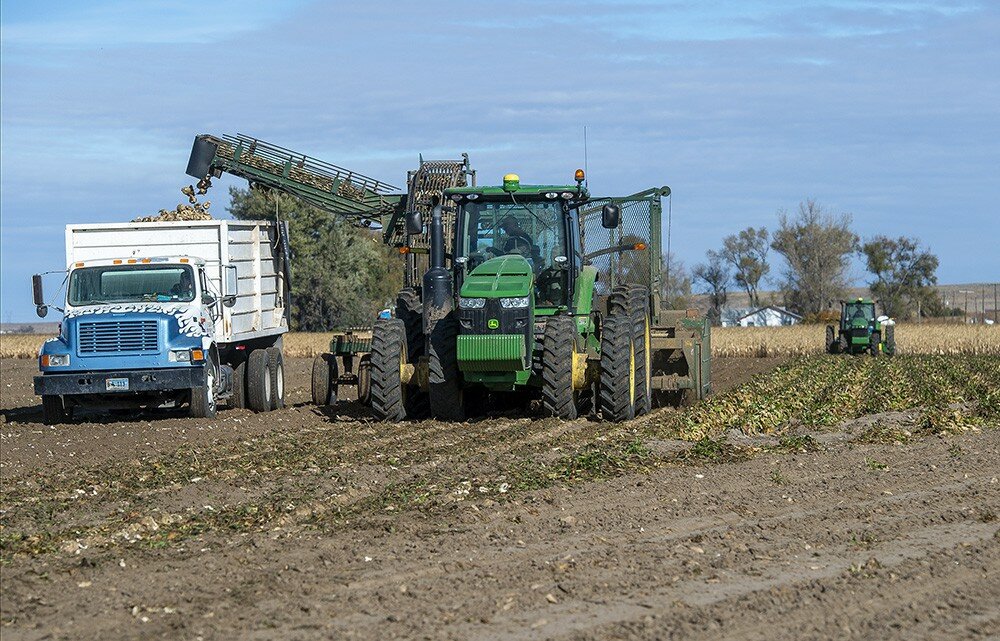
GOSHEN COUNTY – Another series of wintry weather systems are lined up to move through the region in coming days, which could impact producers, even as harvest progresses in what could conservatively be called a difficult growing season.
Brandon Wills, meteorologist with the National Weather Service in Cheyenne, said variable will be the watchword in terms of weather in the near future. From temperatures approaching the 70-degree mark to start off the weekend to a strong chance of snow showers in some areas as early as Sunday, Mother Nature is gearing up to take more shots at the region.
“There’s a good chance of snow showers on Sunday (following) a short-lived warming trend late in the week,” Wills said Tuesday. “Overall, it’s going to be an active weather pattern over the next week or so with temperatures decreasing down to more
seasonal averages.”
The good news is snow is expected only at higher elevations. The other side of that coin, however, is lower elevations can still expect rain, Wills said, all courtesy of a series of cold fronts coming in “quick bursts” from Canada.
“And there will be some moisture associated with this because of the differences in temperature,” he said. “The good thing is, we’re not going to have nearly as cold a snap as we did a couple weeks ago.
“The next weather system is coming into the area on Monday,” Wills said. “Some of the weather models disagree on the exact timing, but it will definitely bring more precipitation from Sunday into Monday.”
This weather system, and those following, are coming even as sugarbeet harvest is moving forward. Jerry Darnell, vice-president of agriculture for the Western Sugar Cooperative in Scottsbluff, Neb., said as of Tuesday morning, harvest was about 60 percent complete on acres in the Nebraska Panhandle and eastern Wyoming.
“We’re moving right along,” Darnell said. “We’re hoping to be about 80 percent complete by Sunday.”
Sugarbeets in the Wyobraska region have apparently recovered well from the cold snap earlier this month that definitively marked the end of the 2019 growing season. The Scottsbluff factory had limited deliveries of frozen sugarbeets from producers for a short time, but is now back at full capacity.
That doesn’t mean the area escaped the negative effects of the cold, however, Darnell said. Harvest issues are making themselves evident across the region from the freeze, he said.
“Most of the beets have healed up (from the freeze) into good, storable shape,” he said. “But the cold makes the top harder to defoliate, so we can get a clean root into the piles.”
Overall, the crop this year is averaging 16.1 percent sugar. During early harvest, the company was projecting 27 tons to the acre, which Darnell said is still the expected yield. The weather during the growing season just didn’t cooperate, he said, leading to the expected reduced yields.
“Sugar is going to be down from last year and tonnage will be down,” Darnell said. “We were projecting that, due to the late spring, the canal issues and quite a few hail storms. Now we had a freeze on top of it – Mother Nature has not cooperated this year.
“But sugarbeets are a great crop to be able to handle different types of stress,” he said. “The root goes down six-feet to mine water.”
Bean, corn yields down
For the other Wyobraska staples, the 2019 dry edible bean harvest is all but done, said Gary Stone, extension educator with the University of Nebraska Panhandle Research and Extension Center in Scottsbluff, Neb. But again, it’s not good news for producers across the region.
“Yields in this area are 40- to 60-percent of normal,” Stone said. “They just haven’t been that good for some reason. I know the hail has been part of it. A couple of my neighbors, when I talked to them about yields, said this was about the worst year they’d ever had.”
There aren’t any current projections for corn harvest, which is just getting underway across the region, said Stone and Carrie Eberle, agronomist with the Hageman Sustainable Agriculture Research and Extension Center in Lingle.
“I haven’t heard any reports on (corn) yields, but it wouldn’t surprise me if they weren’t down, too,” Stone said. “We just didn’t get the hot days we needed” for corn to mature to its full capacity.
Some high-moisture corn, destined for feedlots, is coming out of the fields, Eberle said. But the majority of producers are waiting for the ears to dry down naturally in the field before getting serious about harvest activities. It’s still too early for yield projections, she said.
“The best feel I get for what we’ve got is what our corn on the (SAREC) station does,” Eberle said. “Just driving around, I see a lot of corn still in the fields.
“The whole state this year had some weird conditions – too cool and too wet,” she said. “I just talked to the (Extension) farm manager in Powell. They’re harvesting corn, but it’s still at 30 percent. That’s going to a dairy” operation for feed.
Eberle said it’s difficult to say exactly where this growing season will rank historically. But one thing is clear – it’s definitely not going to be a boom year for producers.
“I haven’t been hearing any stories of complete devastation,” she said. “I also have not been hearing stories of, ‘Oh my gosh, we got the yield we would have expected given perfect growing conditions.’
“Right now, we’re in that window of, ‘Yes, it’s what we expected.’” Eberle said. “There’s not going to be amazing yields, but it’s getting guys to limp along.”
Good moisture in
most of state
Cold and wet conditions were seen across much of Wyoming last week, delaying fieldwork and crop progress, according to the NASS Mountain Regional Field Office in Cheyenne.
Topsoil and subsoil moisture levels were mostly in the adequate to short range. A reporter from Southeastern Wyoming said they got 4-inches of snow, which has forced some feeding. They also indicted harvests were essentially over.
A reporter from Northwestern Wyoming said beet harvest has been slowed due to the freeze.
A reporter from Western Wyoming stated that they have received a lot of moisture in the form of snow, with as much as a foot of snow in the mountains. They also indicated that all harvesting of any grain or hay has come to a stop for the year.
A reporter in Southcentral Wyoming indicated winter appears to be coming early, with most of the cow work done and the hay supplies look good for the most part.
The U.S. drought monitor released on Oct. 17, showed most of Wyoming with good moisture, but with abnormally dry conditions continuing in the Southwest and South Central parts of the state. Irrigation water supply across Wyoming was rated 3 percent poor, 37 percent fair, and 60 percent good. Stock water supplies across Wyoming were rated 3 percent very short, 23 percent short, and 74 percent adequate.


