

Summer heat and a widespread lack of precipitation caused rapid maturation of winter wheat crops across the Panhandle of Nebraska and much of the tri-state region last week.
This item is available in full to subscribers.
To continue reading, you will need to either log in to your subscriber account, or purchase a new subscription.
If you are a current print subscriber, you can set up a free website account and connect your subscription to it by clicking here.
If you are a digital subscriber with an active, online-only subscription then you already have an account here. Just reset your password if you've not yet logged in to your account on this new site.
Otherwise, click here to view your options for subscribing.
Please log in to continue |
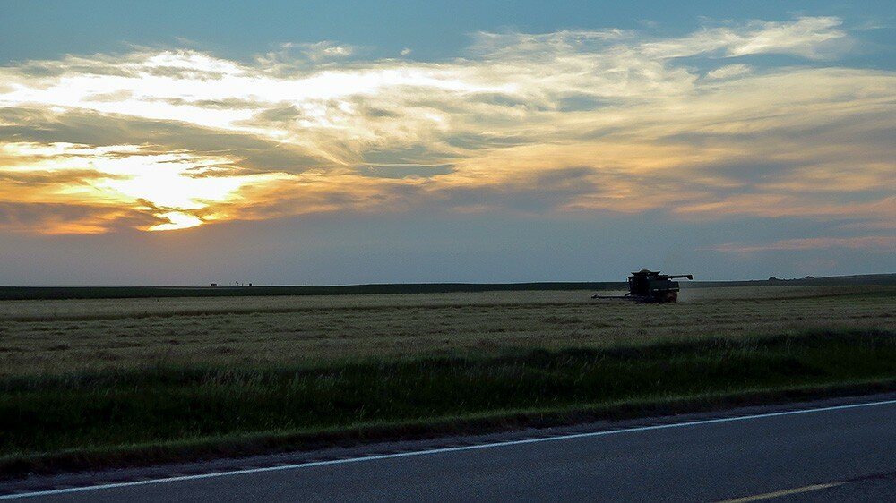
KIMBALL, Neb. – Summer heat and a widespread lack of precipitation caused rapid maturation of winter wheat crops across the Panhandle of Nebraska and much of the tri-state region last week. Hot and dry conditions also pushed spring-planted crop growth and continued to drive warm season grass growth across pastures and rangeland.
By Monday some wheat stands near Kimball had matured enough to harvest and the combines were rolling.
Generally light moisture fell as rain and light hail across the extreme southern Panhandle, mostly south of Interstate 80. Heavier rain and significant hail fell along the Nebraska-Colorado border, with some areas of heavy, localized hail damaging wheat crops.
Daytime heat was significant over the last week, with highs averaging 97 degrees across the Panhandle and slightly higher to the south in Colorado. Fortunately, significant overnight cooling was the norm as well, and overnight lows averaged 55.9 degrees across the Panhandle. Overnight cooling significantly reduces heat stress on livestock and people alike
Regional Forecast and Conditions
The temperature at sunrise Tuesday was 59 degrees under clear skies. Winds were westerly at 5 mph, and the barometer was steady at 30.24 inches of mercury (in/Hg).
Today’s weather (Friday) is expected to be mostly sunny with a 20 percent chance of afternoon and evening thunderstorms. The temperature is expected to rise to 87 degrees before falling off to an overnight low of 60. Saturday and Sunday are expected to be warm and sunny with daytime highs in the low 90’s and overnight lows falling to about 60. There is a slight chance of evening showers forecast for Saturday and Sunday.
Monday through Wednesday are expected to be partly sunny and cooler, with highs in the upper 70’s and overnight lows falling into the mid-50’s. An increased chance of showers is forecast for this period.
Average air temperatures warmed across the region last week. At 13 selected stations across the Panhandle, 24-hour temperatures averaged 76.2 degrees, about 4 degrees warmer than the previous week. At Kimball the July 3-9 daytime high averaged 90 degrees, about 2.25 degrees warmer than the previous week. The weekly high temperature was 96 degrees on July 8. Overnight lows averaged 55.9 degrees, about 1.5 degrees warmer than the previous week. The weekly low temperature was 60 degrees on July 9. The weekly mean temperature at Kimball was 75.85 degrees, about 4.75 degrees warmer than last week, and about 4.75 degrees warmer than the July average of 71.8 degrees. The long-term average high and low temperatures at Kimball for July are 87.4 and 56.1, respectively.
Only three of 13 selected Panhandle stations reported rain over the July 3-9 period. Kimball reported 0.22 inches, Bushnell 0.12 inches, and Sidney 0.09 inches. Across the Panhandle rainfall averaged 0.03 inches, compared to 0.70 inches last week.
With the exception of Sidney, soil temperature warmed markedly across the Panhandle over the July 3-9 period: (this week/last week/change): Alliance 83.3/74.5 (+8.8) degrees; Gordon 80.0/72.5 (+7.5) degrees; Mitchell 80.4/76.1 (+4.3) degrees; Scottsbluff 84.1/76.1 (+8.0); and Sidney 78.0/79.1 (-1.1) degrees.
Winds near Kimball averaged south-southeasterly and mostly light over the July 3-9 period. Gusts for the week averaged 27.42 mph. High gust for the week was 46 mph on July 3.
U.S. Drought Monitor
High Plains: In Colorado and Wyoming, most areas remained unchanged; most of Wyoming remained out of dryness, and conditions worsen progressively moving south, with extreme to exceptional drought covering southern Colorado. Deficient precipitation and enhanced evaporative loss over the past few months led to limited expansion of D0 and D1 in areas near the central part of the border.
Farther east, dryness led to some deterioration in Kansas. D3 pushed into part of south-central Kansas while extreme drought expanded into a larger part of northeastern Kansas.
In the Dakotas, very heavy rains and flooding late in the period covered a swath across east-central South Dakota, leading to a band of 1- to 2-category improvement, with southern reaches of the old D2 area climbing to D0. This area will have to be assessed next week to get a better sense of how this intense rainfall episode changed the drought situation there.
Moderate to heavy rains (but only isolated minor flooding) pelted western North Dakota as well, prompting the removal of abnormal dryness over much of the western part of the state. Small-scale improvements were made in a few other dry areas where rain was heaviest.
West: Outside the withdrawal of D0 from a small area in northeast Montana, where most locations recorded between one and two inches of rain, the Drought Monitor depiction is unchanged from the previous week. Significant rains from the Southwest Monsoon have yet to reach most of Arizona, and only scattered locations across southern and eastern New Mexico recorded over an inch of rain this past week. But a late start to the monsoon is hardly unusual, and conditions do not warrant drought degradation yet.
Near-term forecast: Odds favor above-normal rainfall in central and southern sections of California, the Intermountain West (including the Great Basin), and the Rockies, with surplus precipitation most likely in northern Arizona.
Farther east, wet weather is also favored in the lower Mississippi Valley, most of the Southeast, the southern and eastern Ohio Valley, and the middle Atlantic States. Southern Alaska also has enhanced chances for above-normal precipitation.
In contrast, subnormal rainfall is favored from central and southern Texas northward through the Plains, the western Great Lakes, the northern Intermountain West, and the Pacific Northwest.
Temperatures are expected to average above normal across most of the contiguous states, with the exceptions of southeastern Arizona, southwestern New Mexico, and part of southern Alaska, where cooler than normal conditions seem more likely.
U.S. Conditions and Weather Report
Showers became a little less numerous across the central and eastern U.S., although many areas retained enough soil moisture to support normal crop and pasture growth. Some of the week’s heaviest rain fell across the Deep South and the far upper Midwest.
In places where moisture was lacking, ongoing warmth maintained heavy water demands for crops, especially those entering the reproductive stage of development. Some of the driest regions included the southern High Plains; the mid-South; the southwestern Corn Belt; and the Northeast. Much of Lower Michigan also remained dry.
Mostly dry weather dominated California, the Great Basin, and the Northwest, accompanied by a late-week heat wave that boosted irrigation demands and maintained an elevated risk of wildfires. By week’s end, approximately three dozen Western wildfires, in various stages of containment, had collectively destroyed nearly 500 structures.
Near- to above-normal temperatures covered the entire country, perpetuating a pattern that developed in early May. In the Southwest, pre-monsoon heat boosted temperatures more than 5 degrees above normal in some locations, although late-week cloudiness and showers began to suppress temperatures and reduce the wildfire threat.
Hot weather also prevailed for much of the week from the mid-South into the Northeastern and Mid-Atlantic States. The hottest weather, relative to normal, affected New England, where temperatures averaged as much as 10 degrees above normal.
USDA Weekly Weather and Crop Reports
Colorado
Colorado experienced continued drought conditions across much of the state last week and had diminished water supplies for both irrigated crops and livestock. Western and Central Districts received some isolated rainstorms, however western and southern counties remained in extreme to exceptional drought status. Large fires continued to burn in western and southern Colorado.
In northeastern counties, reports of scattered showers kept pasture and livestock conditions in the good to excellent range. Irrigated crops in these counties seemed to have benefited from the heat with corn, millet, sorghum and feed crops rapidly heading towards maturity. Wheat harvest was also well underway in northeastern Colorado.
Reporters in east-central counties stated that hot and dry weather may have distressed row crop conditions. Wheat harvest was finishing up in Kiowa County by week’s end.
In Southwest Counties, precipitation provided little relief in the exceptional drought conditions they have been experiencing. The showers seem to have helped with ongoing mountain fires.
San Luis Valley reporters noted precipitation ranging from 0” to .25”.
Southeastern counties received spotty moisture last week as well. Barley was mostly headed out and first cutting of alfalfa was almost finished. Potatoes were starting to flower and develop tubers.
In Costilla and Huerfano counties, the Spring Creek fire had burned over 107,000 acres by week’s end and was 70 percent contained.
Statewide, winter wheat harvested was well ahead of the average at 45 percent complete, compared to 28 percent for the five-year average.
Winter wheat was rated 52 percent good to excellent, compared with 43 percent good to excellent last year.
Stored feed supplies were rated 8 percent very short, 25 percent short, and 67 percent adequate.
Sheep death loss was 55 percent average and 45 percent light. Cattle death loss was 70 percent average and 30 percent light.
Nebraska
No report published since mid-May.
Wyoming
Wyoming experienced above normal temperatures for the week. Twenty-six of the 32 reporting stations reported above average temperatures for the week with the high temperature of 102 degrees recorded at Greybull and a low of 28 degrees at Yellowstone.
Below normal moisture was reported at 29 of the 33 reporting stations. Sixteen reporting stations had no precipitation. Newcastle reported the most moisture with 0.78 inches.
A reporter from Western Wyoming noted that it was warm and dry with a lot of alfalfa and grass hay put up. They also mentioned the growing concerns for wildfires.
A reporter from Southwestern Wyoming indicated that the weather has been hot and dry prompting questions from producers about hay and grazing losses.
A reporter from South Central Wyoming indicated that they received hot, dry, and windy weather. They also mentioned that hay harvest is in full swing and pastures are maturing rapidly. Another reporter from South Central Wyoming noted that the hay harvest is ahead of schedule with lower yields due to the hot dry conditions.
A reporter from Southeastern Wyoming indicated that hot temperatures and no moisture persisted until Saturday night. They also mentioned that irrigation water was turned back on which has helped plant growth.
Irrigation water supply across Wyoming was rated 7 percent fair, 90 percent good, and 3 percent excellent.
Stock water supplies across Wyoming were rated 6 percent very short, 16 percent short, 77 percent adequate, and 1 percent surplus.


