

The first hard freeze of the season arrived in Kimball County Sunday night
This item is available in full to subscribers.
To continue reading, you will need to either log in to your subscriber account, or purchase a new subscription.
If you are a current print subscriber, you can set up a free website account and connect your subscription to it by clicking here.
If you are a digital subscriber with an active, online-only subscription then you already have an account here. Just reset your password if you've not yet logged in to your account on this new site.
Otherwise, click here to view your options for subscribing.
Please log in to continue |
KIMBALL – The first hard freeze of the season arrived in Kimball County Sunday night when air temperatures dipped below 28 degrees for about six hours between 1:30 a.m. and 7:30 a.m. Monday night was a near repeat with temps falling to 28 for about four hours. Although the ground didn’t freeze the frosty temps withered leaves on annual forbs and accelerated tree leaf color change and drop. In production ag fields the cold will hasten drydown for corn and sunflower and the remaining hay crop.
In and around Kimball County dryland crops still waiting harvest include mostly corn, sunflowers, and hay.
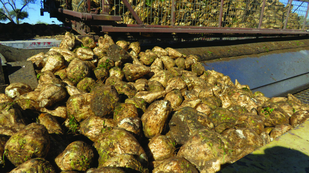
Sugarbeet harvest kicked into high gear over the weekend making the Western Sugar receiving station north of Kimball the busiest place in Kimball County. Thus far sugarbeet producers have been slightly disappointed by yields but also quite pleased with sugar content.
Winter wheat planting in and around Kimball County is essentially complete with very good germination and emergence. Autumnal wheat stands remain quite healthy and a few more weeks of growth before winter dormancy sets in should set the stage for successful overwintering.
Well managed pastures and rangeland in and around Kimball County continue to show a surprising quantity of late-season green. Both cool- and warm-season grasses should continue to photosynthesize and build healthy roots for a few more weeks at least.
Regional Forecast and Conditions
As of Tuesday morning (Oct. 18), the temperature at sunrise was 29 degrees under clear skies. Winds were westerly at 8 mph with the barometer slowly rising through 30.30 inches of mercury (in/Hg).
Today’s weather (Friday, Oct. 21) is forecast to be sunny and breezy with a high of 74 degrees. Friday night should be mostly clear with an overnight low of 40 degrees. Day length will be 10 hours and 54 minutes, night length 13 hours and 6 minutes.
Saturday should also be warm and breezy with a high of 73 and an overnight low of about 39.
Sunday should be partly sunny, breezy, and cooler with a high of 63 and a chance of showers. Sunday night is expected to be cloudy, blustery, and cooler with a chance of rain and/or snow showers. The overnight low is expected to fall to about 29.
Conditions Monday through Wednesday are expected to be somewhat cooler with a continuing chance of rain and/or snow showers. Daily highs may range into the lower 50’s and overnight lows could fall into the 20’s.
At Kimball the Oct. 11-17 daytime high averaged 61.85 degrees, about 4.72 degrees cooler than last week. The weekly high temperature was 74 degrees on Oct. 11. Overnight lows averaged 33.14, about 3.28 degrees cooler than last week. The weekly low temperature was 25 degrees on Oct. 17. The weekly mean temperature at Kimball was 47.5 degrees, about 4.0 degrees cooler than last week and 1.1 degrees cooler than the October average of 48.6 degrees. The 129-year month-to-date (Oct. 1-21) average daily temperature is 48.4, and the highest Oct. 1-21 daily average was 59.7 degrees in 1947, with the lowest 39.8 in 2009. The 129-year average high and low temperatures at Kimball for Oct. are 64.3 and 32.8, respectively.
Kimball received a trace of rain on Oct. 15. Otherwise, it was entirely dry over the Oct. 11-17 period.
Winds near Kimball averaged west northwesterly and often breezy over the Oct. 11-17 period. Gusts for the week averaged 31.28 mph. High gust for the week was 43 mph on Oct. 13.
Historic climate data
Here’s an overview of Oct. 21 temperature and precipitation highs, lows, and averages over the preceding 129 years at Kimball. Data is taken from the High Plains Regional Climate Center (www.hprcc.unl.edu), where you can find and track data for your own particular location.
Last year (Oct. 21, 2021): Daily high temperature 67 degrees, overnight low 33 degrees, average temperature 50 degrees. Precipitation zero inches, snowfall zero inches, snow depth zero inches.
The warmest Oct. 21 on record was 84 degrees in 1921. The coolest Oct. 21 high temperature was 22 degrees in 1906. The coldest Oct. 21 overnight low was 18 degrees in 1976. The warmest Oct. 21 overnight low was 48 degrees in 1941. Over the years since 1893 the high temperature on Oct. 21 has averaged 60 degrees, the overnight low 29 degrees, the daily average 44.1 degrees, precipitation has averaged 0.04 inches, snowfall 0.1 inches, snow depth zero inches.
The highest Oct. 21 precipitation total was 0.54 inches (rain) in 1979. Highest snowfall was 4.0 inches in 1951, highest snow depth 3.0 inches in 1951.
USDA Weekly Weather Bulletin, Oct. 18
Another week with minimal precipitation in many of the nation’s key production areas continued to favor summer crop harvesting and other autumn fieldwork. However, lack of topsoil moisture remained an impediment to the even emergence and proper establishment of recently planted winter grains and cover crops. Expansive dryness also contributed to poor rangeland and pasture conditions, as well as ongoing low water levels in the Mississippi River Basin.
Rain fell in a few areas, however, including parts of the Northeast and Southeast. In fact, rain fell heavily in New England, where 2- to 4-inch totals were common. Southeastern rainfall was generally heaviest in parts of Alabama and Georgia. Portions of the Midwest also received some precipitation, with rain and snow showers noted downwind of the Great Lakes. Late in the week, additional rain developed across the South. Spotty showers occurred from southern California to the southern Rockies, while locally heavy rain fell from western Texas into the mid-South.
For the second week in a row, temperatures averaged at least 5 to 10 degrees above normal in many locations from the Pacific Coast to the northern High Plains. A secondary area of warmth covered the south-central U.S., where temperatures in parts of central, eastern, and southern Texas averaged more than 5 degrees above normal. In contrast, readings averaged as much as 5 degrees below normal in the eastern Corn Belt, Ohio Valley, Southeast, and mid-Atlantic. Exceptions to the Eastern cool pattern included lingering warmth in southern Florida and northern New England. Following the previous week’s Midwestern cold snap, ongoing chilly weather led to additional frost and freezes. In fact, hard freezes (28 degrees or below) were noted in much of the upper Midwest, extending as far south as Iowa, eastern Nebraska, and northern Missouri.
USDA Crop Progress Reports, Oct. 17
Nebraska – For the week ending Oct. 16, 2022, there were 6.5 days suitable for fieldwork. Topsoil moisture supplies rated 46% very short, 36% short, 18% adequate, and 0% surplus. Subsoil moisture supplies rated 47% very short, 37% short, 16% adequate, and 0% surplus.
Corn condition rated 18% very poor, 18% poor, 25% fair, 32% good, and 7% excellent. Corn mature was 94%, near 95% last year, and equal to the five-year average. Harvested was 46%, ahead of 39% last year and 32% average.
Soybeans harvested was 76%, near 74% last year, and ahead of 57% average.
Winter wheat condition rated 16% very poor, 19% poor, 36% fair, 28% good, and 1% excellent. Winter wheat planted was 94%, near 92% both last year and average. Emerged was 73%, near 74% last year and 72% average.
Sorghum condition rated 40% very poor, 24% poor, 17% fair, 15% good, and 4% excellent. Sorghum mature was 87%, behind 93% both last year and average. Harvested was 34%, well behind 55% last year, and near 36% average.
Dry edible beans harvested was 85%, near 88% last year.
Pasture and range conditions rated 52% very poor, 31% poor, 14% fair, 3% good, and 0% excellent.
Wyoming – For the week ending Oct. 16, 2022, precipitation levels were virtually zero for the majority of Wyoming. The exception was in isolated northern portions of the state. Some areas of Johnson, Big Horn, and Sheridan Counties received totals of about 0.2 to 0.4 inches of moisture. Portions of Campbell, Crook, Johnson, Park, and Weston Counties also received some moisture. Levels in these areas were in a range of trace to about 0.15 inches. Temperatures were at or above normal in Wyoming, reaching as much as 8 degrees above average in parts of the west.
Drought conditions showed minimal improvement from last week. According to the US Drought Monitor the amount of land rated drought free increased to 18.7%, compared to 18.2% the previous week. The amount of land rated abnormally dry fell to 34.8%, a decrease 0.3 percentage points from last week. Moderate drought stood at 26.4%, compared to 26.7% the previous week. Severe drought sat at 16.6%, an increase of 0.2 percentage points. Extreme drought was nearly unchanged at 3.5%, compared to 3.6% the previous week.
With the continuing drought in Goshen County, many livestock producers have already grazed their winter pastures and were feeding hay. There were major sales of livestock and deep culling in herds. Calves were being weaned early due to the dry conditions. A fourth cutting of alfalfa was underway in irrigated fields. Moisture was needed in Lincoln County as conditions remained dry and cool.
Irrigation water supplies across the state were rated 24% very poor, 13% poor, 16% fair, and 47% good, compared to 32% very poor, 9% poor, 21% fair, and 38% good last week.
Stock water supplies across Wyoming were rated 14% very short, 46% short, and 40% adequate, compared to 15% very short, 37% short, and 48% adequate last week.
Colorado – For the week ending Oct. 16, 2022, harvest activities progressed quickly across the state thanks to dry, warm weather.
According to the U.S. Drought Monitor for Oct. 11, just over 43% of the state was categorized in moderate drought or worse, down slightly from the previous week. Over 13% of the state is experiencing severe to exceptional drought conditions, equal to last week. The exceptional drought conditions noted across portions of Phillips and Sedgwick Counties remain unchanged from last week, accounting for less than 1% of the state.
Very little measurable moisture was received across the state last week, with southwestern La Plata County garnering the most moisture with 0.15 inches received. Above average temperatures were observed across the state last week, with eastern counties seeing temperatures more than six degrees above average.
Reports on sunflower harvest are mixed, with harvest not yet started in areas of eastern Colorado and quick harvest progress in southwestern Colorado.
Potato harvest in the San Luis Valley advanced last week but continues to progress slower than average. Reporters note recent frosts have stopped alfalfa growth in the area.
Fourth cutting of alfalfa is progressing well in the northeastern and southwestern portions of the state, continuing ahead of the 5-year average. Reporters in the southwestern portion of the state noted alfalfa and corn harvest had slowed to give the crops time to dry from recent rains.
Statewide, planting of the 2023 winter wheat crop was almost complete, with 95% of the crop planted, compared with last year and the 5-year average at 91%. Proso millet harvest is almost complete, with 97% of the crop harvested. The corn crop is almost fully mature, ahead of average and corn for grain harvest progressed well last week, but still falls short of the previous year at 43% and the 5-year average of 34%. Most livestock are still in good condition despite diminishing pasture and rangeland conditions.
Stored feed supplies were rated 10% very short, 30% short, 54% adequate, and 6% surplus. Sheep death loss was 83% average and 17% light. Cattle death loss was 2% heavy, 84% average, and 14% light.
U.S. Drought Monitor
USDM reports derive normals/averages from the most recent 30-year period, though longer timescale data are used where available. The USDM generally reports on current drought conditions and offers a comprehensive history of drought across the Continental U.S. Near-term temperature and precipitation predictions derive from National Weather Service (NWS) and National Oceanic and Atmospheric Administration (NOAA) forecasts.
Current drought status for the Nebraska Panhandle, Southwest Wyoming, and Northeast Colorado. Drought Categories: D0 – abnormally dry. D1 – moderate drought. D2 – severe drought. D3 – extreme drought. D4 – exceptional drought.
(Oct. 11, 2022) Following a drier-than-normal September for a majority of the contiguous U.S., this dry pattern continued into early October for many areas. Therefore, drought coverage increased and intensified throughout the Pacific Northwest, Great Plains, Ohio River Valley, and Southeast. From Oct. 4-10, heavy rainfall (1 to 3 inches) was limited to the northern Mid-Atlantic, southern New England, and parts of the Southwest. New Mexico was especially wet this past week and this much above-normal precipitation extended eastward into west Texas. 7-day temperatures, ending on Oct. 10, averaged above-normal across the West. Cooler-than-normal temperatures were observed from the Mississippi Valley to the East Coast with the first freeze of the season affecting parts of the Midwest.
High Plains: The 30 to 120-day SPI along with soil moisture indicators supported expansion of moderate drought (D1) throughout northern and eastern North Dakota. Based on a consensus of indicators, severe drought (D2) was added to central North Dakota. Severe (D2) to extreme (D3) drought was expanded slightly across east-central Nebraska based on SPI at multiple time scales and soil moisture. Likewise, these indicators supported a 1-category degradation in parts of south-central and southwestern South Dakota. The most widespread degradations made to Kansas were in northeast and east-central parts of the state, consistent with 90 to 120-day SPEI along with soil moisture indicators. An expansion of abnormal dryness (D0) and moderate drought (D1) was made to southeastern Colorado, based on 30-day SPIs, declining soil moisture and streamflows, and very dry VegDRI. Conversely, heavy rainfall (1 to 2 inches) since the beginning of October prompted a 1-category improvement for parts of southwestern Colorado. Slight improvements were justified across northwestern Wyoming, due to positive values of 30 to 90-day SPI and favorable soil moisture response from recent precipitation.
West: Increasing 90-day precipitation deficits of more than 6 inches and above-normal temperatures during September resulted in the continued expansion of moderate drought (D1) across western Washington and northwest Oregon. SPI values, soil moisture indicators, and 28-day streamflows strongly support D1 in these areas. According to the NCEI statewide rankings, Montana had its warmest July-August-September on record. Based on the 90-day SPEI along with 24-month SPI, extreme drought (D3) was expanded across northern Montana. D3 was eliminated in parts of eastern Montana due to the lack of support from SPI and SPEI values at various time scales. Based on longer-term SPIs and local feedback, 1-category improvements were made to parts of Utah along with bordering northeast Nevada.
Near-term forecast: The 6-10-day outlook strongly favors below-normal temperatures across the eastern and south-central U.S. with a persistence of above-normal temperatures over the West. A majority of the contiguous U.S. is likely to experience drier-than-normal conditions with the largest probabilities (50%) for below-normal precipitation forecast across the north-central Great Plains. Elevated probabilities for above-normal precipitation are limited to the Southwest.
Terminology: EDDI – Evaporative Demand Drought Index. This is an experimental model for drought prediction, using nationwide data from 1980-present. SPE – Standardized Precipitation index, correlating present month/year precipitation with 30-plus year historical data. SPEI – Standardized Precipitation Evapotranspiration Index. SWE – Snow Water Equivalent.
For more information on the U.S. Drought Monitor, including an explanation of terminology visit http://droughtmonitor.unl.edu.


