

Much of the region dodged a bullet as an anticipated winter storm last week didn’t hit as hard as early predictions said.
This item is available in full to subscribers.
To continue reading, you will need to either log in to your subscriber account, or purchase a new subscription.
If you are a current print subscriber, you can set up a free website account and connect your subscription to it by clicking here.
If you are a digital subscriber with an active, online-only subscription then you already have an account here. Just reset your password if you've not yet logged in to your account on this new site.
Otherwise, click here to view your options for subscribing.
Please log in to continue |
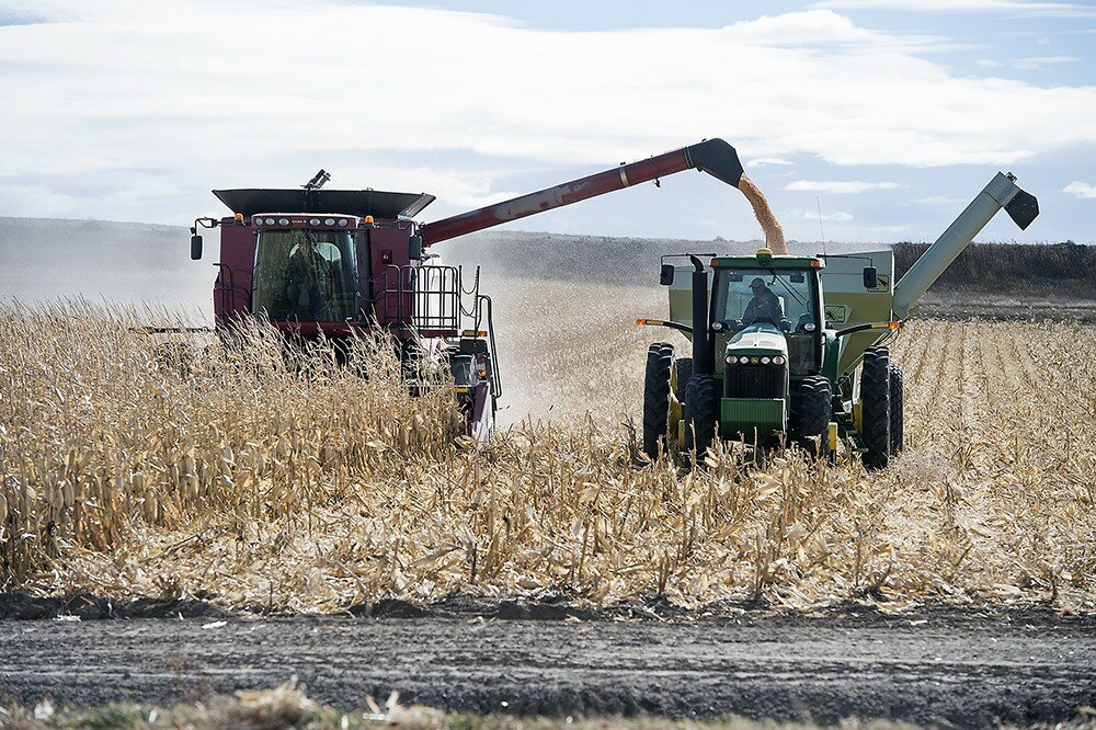
CHEYENNE, Wyo. – Much of the region dodged a bullet as an anticipated winter storm last week didn’t hit as hard as early predictions said.
The storm was “pretty typical for this time of year,” said meteorologist Jerry Claycomb with the National Weather Service in Cheyenne. “The system tracked a bit further north than what we were thinking it would and (moved through the area) a lot faster.”
The bulk of the storm hit the Pine Ridge region of northwest Nebraska, which reported as much as 12 inches of snow. Portions of the storm line dumped as much as five inches in areas of Laramie County and around Cheyenne, including measurements of three inches at the Cheyenne Airport, where the National Weather Service is officed, Claycomb said.
Snowfall amounts from the storm varied in Goshen County, from an inch in southwestern Goshen County to 3.5-inches north of Hawk Springs. Warm weather in the days before the storm moved in means the actual totals may be greater, Claycomb said. Warm air means warm ground, which probably melted some of the first flakes that hit the ground in eastern Wyoming and western Nebraska, skewing the final snowfall totals.
“That’s pretty typical for these early-season storms,” Claycomb said. “The ground is just too warm. As we get deeper into the winter season, the ground will be colder. A lot more of that snow will remain.”
While the timing of the storm wasn’t out of the ordinary, 2019 has been anything but an average weather year, Claycomb said. Since Jan. 1, the NWS office in Cheyenne has issued more than 400 severe thunderstorm warnings.
“We’ve never done that before,” he said. “We’ve never had that many warnings for a season. It was pretty active for us.”
Part of the cause for the unusual weather year was a weak El Nino pattern that developed in the opening months of 2019, Claycomb said. That drove the regional climate “straight into the monsoon season.”
Weather fronts originating in Canada typically keep the region cool and damp into early May. Then they retreat back north to be replaced by dry weather systems from the desert southwest, he said. When monsoon season kicks in, moisture out of Mexico and the Gulf of California triggers rains later in the season.
“That keeps us dry through probably June or so,” Claycomb said. “But that started earlier this year – it started in June and persisted through most of the summer.”
That was a mixed blessing for farmers, particularly those who lost irrigation water in July following the tunnel collapse on the Gering-Fort Laramie Canal, said Dr. Cody Creech, a dryland cropping specialist at the University of Nebraska Panhandle Research and Extension Center in Scottsbluff, Neb.
“The question on the canal collapse would be if the fields were able to get water before the canal went out,” Creech said. “The fields that didn’t get water prior to the collapse, those fields are going to hurt a little more We got really fortunate with the timely rains that helped out.”
Still, Creech wouldn’t be surprised to see losses of 15 to 20 percent over last years yields around the Wyo-Braska region. But, fortunately, the most recent storm didn’t have as many negative effects on farmers as it could have.
“The thing that could have happened is (snow) weighing down stalks,” said Carrie Eberle, Assistant Professor of Agronomy and Cropping Systems with the University of Wyoming at the James C. Hageman Sustainable Agriculture Research and Extension Center in Lingle, Wyo.
“Having ears on the ground – once that happens, it’s pretty hard to recover from it,” Eberle said. “And I think the weather conditions while the canal was down really helped delay the drought stress those crops were having.”
Most of the Wyoming corn crop – 75 percent – had reached maturity by the time freezing temperatures hit, according to the Oct. 7 Wyoming Crop Progress Report from the U.S. Department of Agriculture National Agricultural Statistics Service field office in Cheyenne. After that point, all freezing temperatures will do is help dry the plants down in preparation for harvest, Eberle said.
The crop is “mature – not ready to harvest but mature to the point where having cold on it should not significantly impact it, at this point,” she said.
Even with everything, there were a couple of bright spots for some producers this year, Eberle and Creech said. For one, dryland farmers outside the Platte River Valley could see a bumper crop this year, Creech said.
“The summer really helped the dryland crops, because we had better moisture,” he said. “Dryland yields outside the Valley are going to be really nice this year. A lot of those fields will be breaking 100 bushels this year.
“To say overall, are we going to see more corn or less produced this year?” Creech said. “I don’t know. I feel those dryland acres are going to make up some of that difference this year.”
Another advantage to the cooler, wetter summer was reduced heat stress, decreasing demand for irrigation water that wasn’t there in parts of the Valley, Eberle said. Particularly for the producers who lost water in the canal shutdown, “even a quarter-inch of rain can delay some of those drought impacts,” she said. “I think the weather conditions while the canal was down really helped delay the drought stress those crops were having.”
And if anyone is going to see a benefit from this first storm of the season, it’s winter wheat producers, Creech said.
“Nothing about this storm, as brief as it was, would concern me about the wheat crop; the moisture could be seen as a positive for some of that wheat,” he said. “If it warms up next week, that moisture could definitely be a benefit.”
But Eberle and Creech both said, regardless of whether they were impacted by canal or not, the weather all season will definitely take a toll on production this year.
“The bottom line is – corn likes heat,” Creech said. “We’re going to see yields off just because we didn’t have all the heat it likes to have.”
Neb. crops
progressing well
LINCOLN, Neb. – For the week ending Oct. 13, there were
4.3 days suitable for fieldwork, according to the USDA’s National Agricultural Statistics Service regional office in Lincoln. Topsoil moisture supplies rated 1 percent very short, 7 short, 79 adequate, and 13 surplus. Subsoil moisture supplies rated 1 percent very short, 6 short, 79 adequate, and 14 surplus.
Field Crops Report
Corn condition rated 3 percent very poor, 6 poor, 20 fair, 51 good, and 20 excellent. Corn mature was 85 percent, behind 95 last year and 92 for the five-year average. Harvested was 20 percent, behind 25 last year, and near 24 average.
Soybean condition rated 2 percent very poor, 5 poor, 21 fair, 58 good, and 14 excellent. Soybeans dropping leaves was 91 percent, behind 97 both last year and average. Harvested was 28 percent, behind 38 last year and 47 average.
Winter wheat planted was 95 percent, ahead of 89 last year, and near 92 average. Emerged was 66 percent, behind 73 last year and 75 average.
Sorghum condition rated 2 percent very poor, 2 poor, 14 fair, 66 good, and 16 excellent. Sorghum mature was 82 percent, behind 94 last year and 92 average. Harvested was 10 percent, well behind 31 last year, and behind 26 average.
Dry edible beans harvested was 87 percent.
Pasture and Range Report
Pasture and range conditions rated 1 percent very poor, 3 poor, 14 fair, 59 good, and 23 excellent.
Weather delays Cowboy State harvest
CHEYENNE, Wyo. – Cold and wet conditions were seen across much of Wyoming last week, delaying fieldwork and crop progress, according to the NASS Mountain Regional Field Office in Cheyenne.
Topsoil and subsoil moisture levels were mostly in the adequate to short range, however soil moisture improvement was seen last week.
A reporter from Southeastern Wyoming said fluctuating temperatures were the norm last week. Freezing temperatures early on were followed by warm temperatures, reaching the 60s and 70s in some parts of the region. The area’s corn has yet to dry out enough for harvest.
The corn crop statewide was reportedly 91 percent mature, with 89 percent of the silage crop harvested. That compares to 75 percent and 79 percent last week, respectively. Maturity for the period was slightly ahead of the 89 percent reported last year at this time, and well ahead of the 80 percent average over the previous five years.
Dry edible beans were 84 percent cut and 74 percent harvested for the period, ahead of the 79 percent and 70 percent, respectively, last year, but behind last year’s numbers, when 100 percent of the crop was cut by this time and 95 percent was harvested.
Sugar beet harvest lagged behind last year, with 22 percent harvested, compared to 48 percent of the crop last year.
“We had some damage” from the freeze, said Jerry Darnell, vice president for agriculture for the Western Sugar Cooperative in Scottsbluff, Neb. As of Wednesday, the company was still buying beets on allocation, but had curtailed processing to give the roots a chance to recover from the cold.
“We’re allowing the beets to heal up right now,” he said. “We’re hoping to resume full harvest this weekend.”
Sugarbeets across eastern Wyoming and the Nebraska Panhandle were impacted by the cold snap, Darnell said. The freeze stops growth in the plant.
“There probably will be no additional tonnage or sugar put on” from this point, Darnell said. “We’ll move forward and get the sugar we can out of the beets.
“This takes the potential for additional gain out of the equation,” he said. “We’re estimating a 27-ton crop with 16.5 percent sugar.”
A reporter from Western Wyoming said producers were trying to get the third cutting of alfalfa completed but, due to the wet and freezing conditions, harvest was postponed. In southern Wyoming, a reporter stated that temperatures reached freezing levels every night with small snowstorms seen throughout the week. The U.S. drought monitor released on Oct. 10, showed most of Wyoming with good moisture, but with abnormally dry conditions in the Western, Southwestern and South Central parts of the state. Irrigation water supply across Wyoming was rated 4 percent poor, 28 percent fair, and 68 percent good. Stock water supplies across Wyoming were rated 7 percent very short, 22 percent short, and 71 percent adequate.
Colorado
harvest moves forward
LAKEWOOD, Colo. – Fall harvest made significant progress last week, amidst an early fall snowstorm, according to the NASS Mountain Region Field Office in Lakewood.
Several areas also observed their first hard freeze and record-low temperatures were set in many localities. Northeastern county reporters noted sugarbeet harvest was fully underway last week, and harvest of corn, sorghum, and sunflowers also picked up. Freezing temperatures last week aided dry down of crops yet to be harvested.
Counties in the area received scattered rain and enough snow to accumulate. Reports from the east-central counties noted low temperatures between 10 and 15 degrees were observed, along with snowy and windy conditions. Producers continued fall seeding and harvest activities around inclement weather.
In southwestern counties, a reporter noted drought conditions worsened and minimal precipitation was received. According to the latest U.S. Drought Monitor report, severe drought was introduced across several southwestern counties and moderate drought conditions also expanded in northwestern counties.
In the San Luis Valley, producers rushed to wrap up fall potato harvest before the big freeze, according to reports. Although potato harvest approached completion mid-week, producers who did not finish in time would likely see some freeze damage on the crop.
Precipitation was minimal, with observed temperatures down to single digits.
In southeastern counties, reporters observed a very hard freeze, bringing crops to maturity. Corn harvest also started to pick up.
Livestock producers continued seasonal weaning activities, but some heavy sickness in calves was observed due to the large temperature swings. Statewide, stored feed supplies were rated 3 percent short, 80 percent adequate, and 17 percent surplus.
Sheep death loss was 2 percent heavy, 67 percent average, and 31 percent light. Cattle death loss was 68 percent average and 32 percent light.


